GIS monitoring tool for coordination of mobility measures from SUMP (Brno, Czechia)

Area: urban
Date implemented: The development of GIS monitoring tool was done from September 2019 to March 2020.
How long from concept to implementation: 4 years
Relation between efforts undertaken and benefits achieved: good
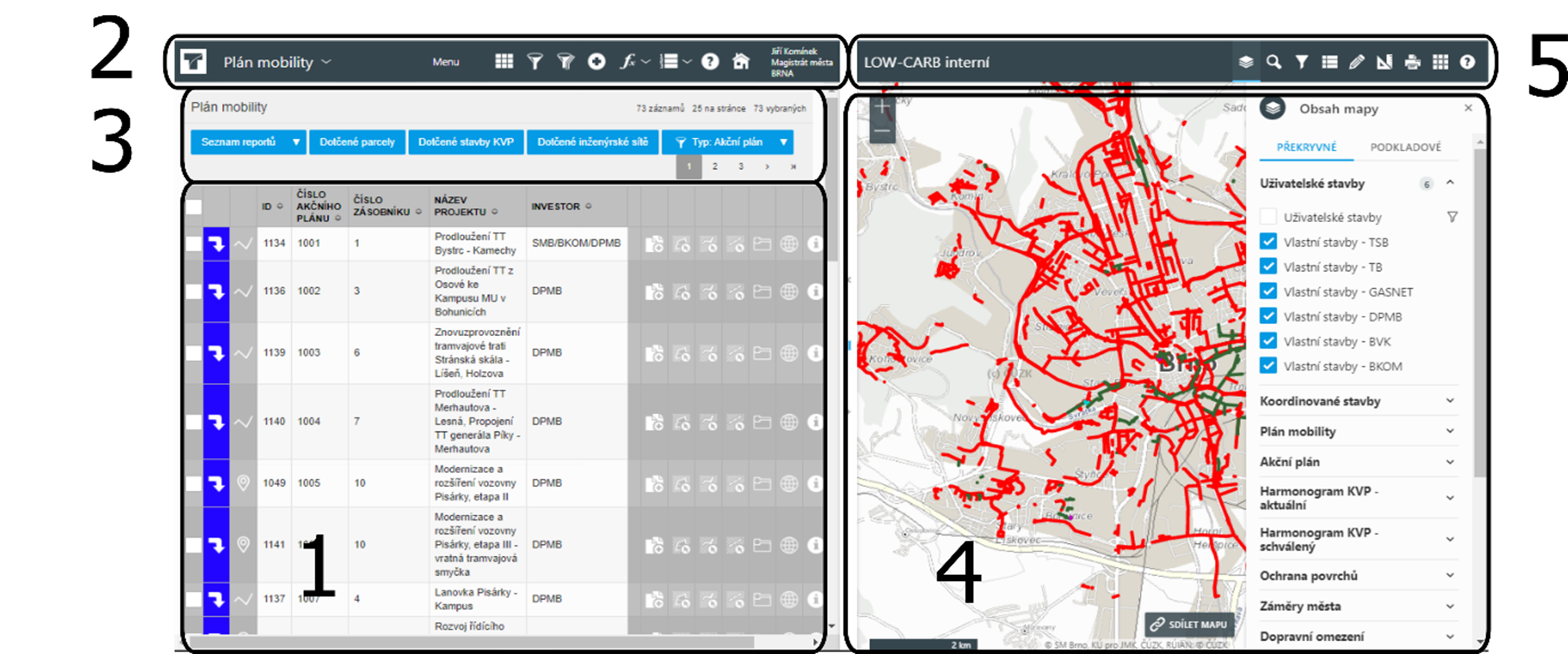
What was done and how: GIS monitoring tool is used within the process of preparing an Action Plan. The tool helps with better monitoring and evaluation of measures. There is also clearer responsibility and, for example, the measure budgets clearly shown. The monitoring is mainly used for work, but a public version is also available to inform citizens. It is easy to change measures and add information, and work on the Action Plan will be easier in the future. The monitoring tool allows cooperation among all stakeholders simultaneously, so there will be significant time saving and better coordination of implementation. It also accommodates citizen participation in the proposal of new measures in the Action Plan.
Why it worked to 'fast track' the innovation/measure: assistance with monitoring and evaluating measures.
Lessons learnt: a GIS monitoring tool is not suitable for all measures, e.g. for small measures and urgent measures, such as water or gas accidents. There is a culture of using Excel, and using a new tool was something new for users.
Tips for replication: a SUMP monitoring tool is good for developing and implementing an Action Plan and a package of SUMP measures, because information about measures don’t change often and therefore work on the tool is not too demanding and willingness to put information into tool is higher.
Sources or links:
Date implemented: The development of GIS monitoring tool was done from September 2019 to March 2020.
How long from concept to implementation: 4 years
Relation between efforts undertaken and benefits achieved: good
What was done and how: GIS monitoring tool is used within the process of preparing an Action Plan. The tool helps with better monitoring and evaluation of measures. There is also clearer responsibility and, for example, the measure budgets clearly shown. The monitoring is mainly used for work, but a public version is also available to inform citizens. It is easy to change measures and add information, and work on the Action Plan will be easier in the future. The monitoring tool allows cooperation among all stakeholders simultaneously, so there will be significant time saving and better coordination of implementation. It also accommodates citizen participation in the proposal of new measures in the Action Plan.
Why it worked to 'fast track' the innovation/measure: assistance with monitoring and evaluating measures.
Lessons learnt: a GIS monitoring tool is not suitable for all measures, e.g. for small measures and urgent measures, such as water or gas accidents. There is a culture of using Excel, and using a new tool was something new for users.
Tips for replication: a SUMP monitoring tool is good for developing and implementing an Action Plan and a package of SUMP measures, because information about measures don’t change often and therefore work on the tool is not too demanding and willingness to put information into tool is higher.
Sources or links:


